Earth, point and click
Spent a little while tinkering with Maxmind’s GeoLite City geolocation database and Indiemapper‘s Flash-based GIS mapping tool. I’d prefer to render the base map myself, using the free Natural Earth shapefiles, but after deciding to use the Winkel Tripel projection with the Perl bindings for the Proj.4 library (for which the appropriate incantation appears to be “+proj=wintri +lon_0=90w +x_0=16396891.17 +y_0=10018754.17”), I ran out of idle-hacking energy when Asia wrapped around the edges. Something to do with urgent calls from a panicked customer-service manager whose migration plan had suddenly turned into a bad ending from Oregon Trail.
Anyway, despite the horrible performance, excessive memory usage, and utterly crap UI of a Flash app, Indiemapper is quite useful, and for people who frequently generate maps with less than, say, 10,000 data points per layer, it’s probably worth the monthly subscription fee. It’s definitely worth the free 30-day demo.

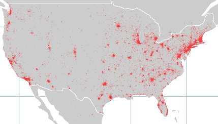
Below, I’ve added a close-up of the US, to answer Steven’s question (note: it took less than a minute to login to Indiemapper, load my previously-saved map, change the projection to Mercator, zoom in on the US, and export a new PNG; it’s a lot more comfortable with countries than with planets):
