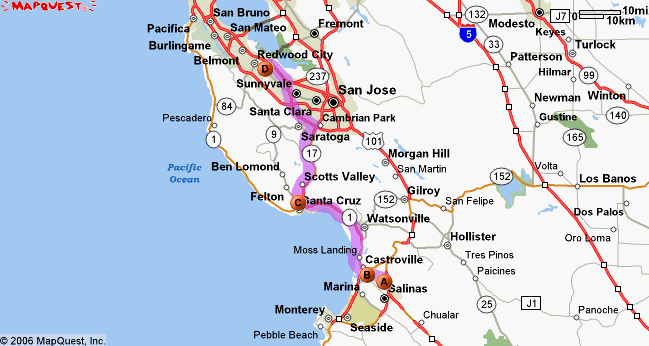
From Point A to Point B
I am here, at the corner of Boronda and N. Main in Salinas. I wish to go here, to a parking garage in Palo Alto.
Yahoo thinks I should take US-101 to CA-85 to I-280 to Page Mill Road to Alma to University. 76.2 miles, 78 minutes.
Mapquest thinks I should take US-101 to University. 74.32 miles, 78 minutes.
I recently upgraded my car’s GPS navigation system, replacing the 2001 software with the 2005 version. Before the upgrade, it thought I should take US-101 to Oregon Expressway to Middlefield to University, which (perhaps accidentally) recognizes that University is a lousy place to get off the highway. It was a good route.
Imagine my surprise when the four-years-newer firmware proposed the following route: US-101 to Espinosa to Castroville Road to CA-1 to CA-17 to CA-85 to US-101 to University. 78.25 miles, 95 minutes.

This is not a “scenic route” option; the car thinks it’s offering good advice, despite the fact that you can persuade it to admit that both Yahoo’s and Mapquest’s suggestions are both shorter and faster. They’ve significantly changed the way they weight different roads, and I haven’t figured out where the “don’t be stupid” button is.
And I need to, because this is a mind-bogglingly stupid route, starting with the very first turn. Espinosa is a two-lane highway with heavy farm traffic, and getting onto it from US-101 requires making a left turn across southbound traffic, from a full stop. When you eventually make it to Castroville, the speed limit in town is 25mph. CA-1 is two lanes of lovely coastal highway up to Santa Cruz, with lots of trucks struggling to navigate the hills and curves. CA-17 is a very pretty—and ridiculously crowded—drive through the Santa Cruz Mountains. CA-85 isn’t nearly as bad as it used to be, but even with the recent improvements, merging back onto US-101 at the north end can be messy during rush hour.
Unfortunately, my ability to control routing decisions is limited to flavor (“shortest”, “fastest”, “maximize highway”) and “avoid this road”. I don’t want to tell it to avoid Espinosa, because when it’s not rush hour, it’s the fastest route to the Borders in Seaside, and it’s always the fastest way back from the coast.
[update: when calculating the B-to-A route, the new version of the software agrees with the old one, and combining that with the Mapquest picture gives me a pretty good clue about what’s going on. I think US-101 between Salinas and Watsonville is being weighted as a non-highway road, making Espinosa/Castroville the shortest path to a highway. Either the old data gave that stretch of 101 a better rating, or the new software optimizes for starting road conditions at the expense of overall trip quality.
So, if I tell it to avoid the stretch of Castroville Road just before CA-1 North, it should change the weights enough to send me up 101 when going to Palo Alto without interfering with route planning to Seaside. The potential downside is that it might try to route me up 101 to CA-17 to reach Santa Cruz, but that depends on just how heavily it weights the “avoid this road” markers.]
[update: oh, this is getting good. I set an “avoid this area” marker on Castroville Road just past the 156 south exit, so it wouldn’t interfere with routing to Seaside and Monterey. The car recommended taking 156 south to the next exit to get onto CA-1.
So I moved the marker a bit further down the road, past that exit, and the car took 156 south a bit further to reach CA-1. So I moved the “avoid this area” marker onto CA-1, and the car routed through Hollister.
Along San Juan Grade Road. This is a paved goat path running through the Gabilan Mountains.
However, if I remove all of the “avoid” markers and set a waypoint along 101 near San Juan Batista, the car gives me a perfectly sensible route, which it admits is shorter and faster than all previous recommendations (74 miles, 69 minutes).]